The clifftops
Add to my favorites

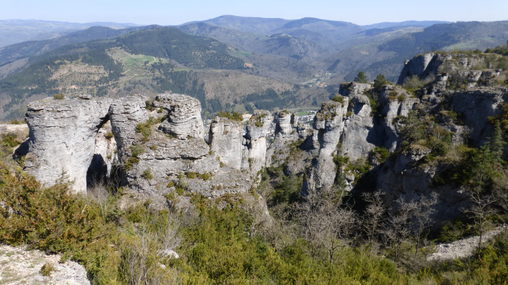
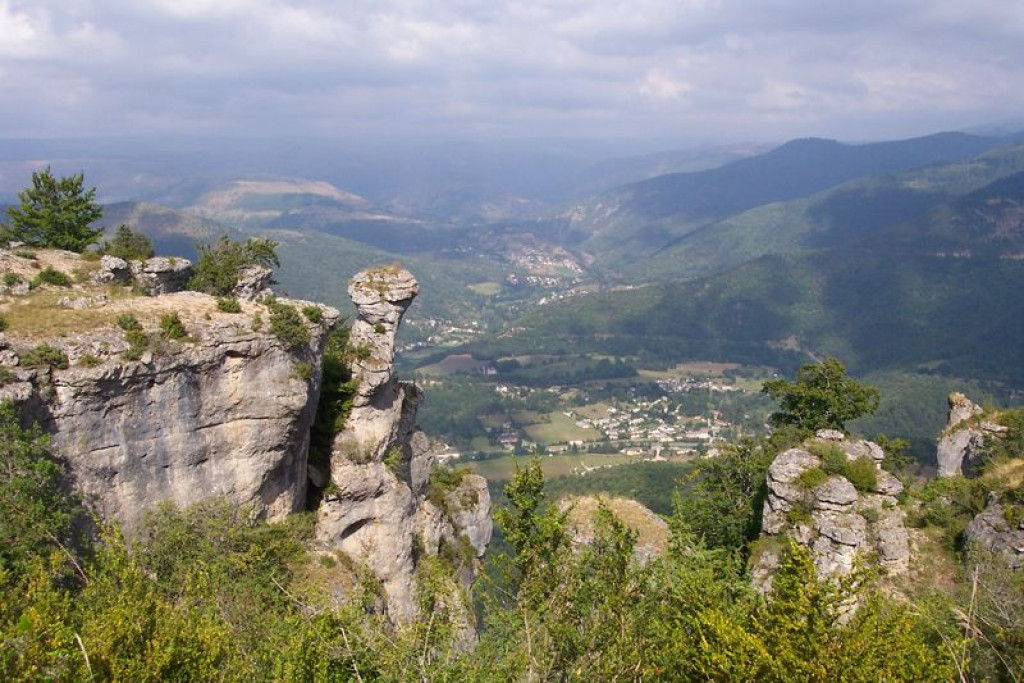
This trail leads at the foot of the plateau of the Causse Méjean, which offers viewpoints towering over the valley of Florac and the spectacular “crowns”. On the horizon, the Cévennes and Mont Lozère stand out as a series of planes to infinity.
A unmissable trail starting from Florac, with a wealth of natural and heritage points of interest, and landscapes that are as varied as they are spectacular.
The characteristics of the route.

Florac (48)
- Distance 14.46 km
- Elevation gain 650 m
- Elevation lost 650 m
- Min. elevation 535 m
- Max. elevation. 1038 m
- Duration (depending on pace) 6h
- Suivre le balisage Yes

Starting at the Maison du tourisme et du Parc (joint tourism office and National Park information centre) in Florac-Trois-Rivières, cross the RN 106 main road. Take the metal footbridge and keep straight ahead until you reach the Esplanade. Turn left and walk to the square. Take Rue du Quai and, at the crossroad, go straight ahead onto Rue de Remuret, which goes uphill to the Catholic church. Keep going uphill until you reach the D 16 road.
Parking : Carpark below the cemetery on the Causse road.
- Turn left onto the road, and go past the council workshops and the entrance to Paul Arnal Park. After the bend, turn left. 200m later, the path rejoins the D 16. Cross the road and continue to climb straight ahead, crossing the road 4 times.
- Below the ledge of the Causse plateau, head towards Mas Rouchet for 80 m. Then turn left onto the path leading to the dolmen on the edge of the Causse road. Turn left onto the road and follow it to the hairpin bend.
- Follow the path that goes below the Causse ledge. For the first 400 m approximately, the path is steep and built with steps. Then it goes across the slope below the plateau ledge to the via ferrata at Le Rochefort.
- Once on the flat area, ignore the path that goes up onto the Causse and go straight ahead on the path that hugs the slope, below the plateau ledge but above the cliffs.
- At the crossing, take the path on the left that zigzags downhill amidst the cliffs to the hamlet of Croupillac.
- Above the hamlet, the path veers left. At the far side of the meadow, turn left, go through the electric fence and follow the path that stays at mid-height on the side of the Causse. (NB: horse pasture, electric fence). The path crosses a track, goes downhill on the right, then goes through a meadow and rejoins the track.*
- 80m later, you leave the track, turning onto a path on the right, which zigzags downhill towards the hamlet of Le Viala de Grimoald. At the path, turn right and, at the road, turn left, going uphill towards the houses. Once you have left the hamlet, turn right: the path joins up with the D 907.
- Turn left to return to Florac. At the roundabout, go straight. As you reach the Collège (secondary school), fork left onto Rue du Pécher, then return to the Esplanade and the joint tourism office and National Park information centre.
Parking : Carpark below the cemetery on the Causse road.
Area : Cévennes et Mont Lozère
Report a problem
Pdf file THIS ROUTE IN YOUR MOBILE PHONE
Download Lozère Outdoor app
Get all the routes on your smartphone with the Lozère outdoor app. You'll find all outdoor activities (summer and winter seasons) and a host of functions :
- Take advantage of detailed IGN maps
- Download data for consultation even when you're not connected to the network
- Geolocate yourself at any time on the route and altimeter profile
- Activate the off-track alarm to be alerted if you stray from the itinerary
- Share your experience (add a report, share your lap time)...

Add your time and share your feelings


Follow us on
the digital trails
the digital trails


![]()
The Lozère Outdoor application was created
by the Lozère Department
Infos & contacts
Conseil départemental de la Lozère
sportsnature@lozere.fr
+33(0)4 66 49 66 32
Crédits photos
 Lozère Outdoor - Parcours - The clifftops
Hello, world! This is a toast message.
Lozère Outdoor - Parcours - The clifftops
Hello, world! This is a toast message.
Lozère Outdoor - Parcours - The clifftops
Hello, world! This is a toast message.


OK
Annuler